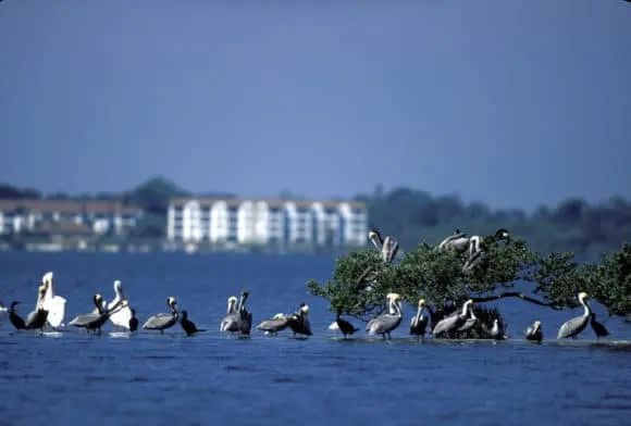
The nation’s first National Wildlife Refuge was created by President Teddy Roosevelt in 1903 in an effort to ban the slaughter of pelicans, ibis and egrets for their plumage.
Hats with feathers were all the rage at the turn of the century, and poachers hunted many species of birds to the brink of extinction to satisfy demand.
Roosevelt signed an executive order in 1903, the first of its kind, that banned hunting on the island, viewed by conservationists as the last breeding ground for pelicans on the east coast.
Before the end of his presidency, he would go on to create 55 more wildlife refuges across the country, including nine in Florida.
Initially, the declaration did little to stop the poachers, and protecting the pelicans that flocked here was a dangerous job. Two wardens were killed in those early years, until a local boat builder named Paul Kroegel came along, armed and ready to defend the island and its feathered inhabitants.
During the 1960s, this sanctuary once again faced a threat by man as developers moved into the area, seeking to purchase and build on the wetlands and islands surrounding Pelican Island.
Local citrus growers, commercial fisherman and sportsmen, aided by the Florida Audubon Society, convinced the state to expand the refuge to include more than 5,000 acres of diverse habitats on western Orchid Island and submerged lands in the Indian River Lagoon around the island.
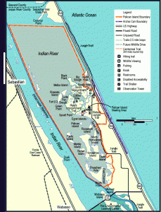
Pelican Island is not accessible from shore, but the surrounding preserve includes restrooms, a parking lot, a 2.5-mile nature trail and a boardwalk that goes out to an observation tower overlooking the island.
More than 30 species of birds currently use Pelican Island as a rookery, roost or feeding ground, and 16 species nest here, including pelicans, wood storks, several varieties of egrets and herons, as well as the double-crested cormorant, anhinga and the American oystercatcher.
Pelican Island is located in the Indian River Lagoon, the most biologically diverse estuary in the country, wedged as it is in overlapping temperate and sub-tropical climates. The result is a diverse eco-system that features seagrass beds, oyster bars, mangrove islands, salt marsh, and maritime hammocks.
Approaching the island by kayak, canoe or small boat
While you are prohibited from landing on the island, you can get close enough to view the prolific wildlife, take photographs and check off a few species on your bird list.
My recommended approach to the island is by kayak or paddleboard. Shallow waters throughout the refuge restrict access by larger boats.
Launch points
[mappress mapid=”488″ alignment=”left”]Sebastian Inlet State Park. The launch ramp is located within the state park on the south side of Sebastian Inlet. Paddle south from the launch on the Indian River, across the open bay and around the first group of islands you encounter. Straight ahead is Pelican Island and the Pelican Island National Wildlife Refuge on the east side of the Indian River. Note that you may find yourself in shallow water, so it’s best to keep away from shore.
You may also want to visit the string of spoil islands on the west side of the waterway, where you can put ashore and picnic.
If you don’t have your own kayak, rent one from the park concession at the Bayside Marina, which is located just across the bridge on the north side of the inlet. For more information, call (321) 724-5424 or visit their web site.
Main Street Park, Main Street at Indian River Drive, Sebastian. This may be the closest ramp to Pelican Island, but it’s also a busy launch area for motorboats. From the ramp, paddle south along a string of spoil islands. At the last island, turn east toward the observation tower in the Pelican Island National Wildlife Refuge. Pelican Island is right there below the tower.
While you will be unable to land on Pelican Island, you can paddle back to the spoil island and beach your kayak for a picnic.
Wabasso Island Causeway. This park on the causeway to Orchid Island (SR 510) is about three miles south of Pelican Island, but it really makes an excellent base camp for your paddle into the refuge or elsewhere on the Indian River. The causeway features beaches, docks, boat launch and picnic pavilions.
Paddle north under the causeway bridge to the north side of Wabasso Island, then veer east to the East Channel. (The Intracoastal Waterway is in the West Channel.) Follow the East Channel through the mangroves about four miles until you see the refuge’s observation tower. Pelican Island is the small island just west of the tower.
Another option is to contact Tropical Kayak Tours of Vero Beach, which offers kayak rentals and tours to Pelican Island on request for small groups. Phone: (772) 778-3044
Fishing and clamming

Fishing is permitted in the open water areas of the Refuge. The Lagoon is a breeding ground for wildlife above and below the water, and you are close to Sebastian Inlet, where sportfish migrate into and out of the Lagoon on the tides. The prime location for inlet fishing is Sebastian Inlet State Park.
Popular catches are redfish, snook, sea trout, and mangrove snapper.
Recreational shellfish harvesting is permitted within the refuge, although you cannot use rakes, and you must steer clear of commercially leased areas, which are marked. My wife and I have gone clamming in these waters many times with friends, although we didn’t know we were in the refuge at the time.
Leased areas for clam and oyster farming are marked. Stay clear. They provide a livelihood for many area residents.
If you don’t have a kayak, you can access the refuge’s shallow clam and oyster beds from State Road A1A, below Sebastian Inlet and above Pelican Island. Wear socks and wade out into the mud. You can feel the clams beneath your feet, and the water is shallow enough where you can reach down and pick them up with your hands once you find them.
This is a broad, shallow area with acres and acres of clam beds, and you’ll have better pickings the farther out you wade. Bring a tube or a kayak to hold onto and just poke around in the mud. Some folks like to show off and pick the clams up with their toes. I’m not that good, but I am picky. I prefer the smaller clams for steaming.
We set up a Coleman stove and steamed them on shore as we passed the afternoon away. What a great day that was!
The Florida Fish and Wildlife Conservation Commission regulates recreational shellfish harvesting in the Indian River, so it would be prudent to familiarize yourself with the rules by visiting this web page.
Campgrounds
Within a few miles the Pelican Island Wildlife Refuge, there are several public campgrounds where you can pitch a tent or park an RV.
Adventurous boaters can also camp on the spoil islands across the Intracoastal Waterway (Indian River). Spoil islands are the product of channel dredging in years past, and most are overgrown with trees and underbrush.
Some of the islands even have designated campsites with picnic tables and fire rings. For more information, visit the Spoil Island Project’s web site.
[mappress mapid=”78″ alignment=”right”]Sebastian Inlet State Park, 9700 South Highway A.1.A., Melbourne Beach. 51 renovated campsites overlook the inlet for both RVs and tents. Shade is sparse. All sites have water and electric, but no sewer hookups. There is a dump station on site, and rest rooms with showers are convenient to all campers. A camp store sells the basics, including bait for fishing. Sebastian Inlet State Park is divided into two sectors. The campground entrance is south of the inlet, and it has its own boat ramp. Another boat ramp is available at the park’s marina on north side of the inlet, primarily destination for day visitors. Campsites are $28 a night plus taxes, utility fees and a reservation fee of $6.70, and sites may be reserved up to 11 months in advance by phone (800) 326-3521
Long Point County Park (Brevard County), 700 Long Point Road, Melbourne Beach. One of my favorite campgrounds, Long Point Park is about one mile north of Sebastian Inlet State Park, just off State Road A1A. The campground is on an island in the Indian River, and a majority of the campsites are waterfront with access to launch your kayak or moor your motorboat. If you get an inside site, there is a boat launch on one side of the park. All sites have water and electric. Bring your own shade, a must-have accessory towards summer, when you can still experience a refreshing sea breeze. Food, beer and bait is available at a nearby convenience store. Camping fees are $28 per night (plus tax) and reservations can be made up to one year in advance by phone: (321) 952-4532
Donald McDonald Campground Park, 12315 Roseland Road, Sebastian. A very nice, wooded and shaded public campground with boating access to the Sebastian River. Although most of the campsites are improved with fire pits and picnic tables, only five have electric and water hookups for RVs. All are accessible by motor vehicle. This campground is not well-known or heavily used, so sites are almost always available, according to locals. In the tent loop, potable water is available from conveniently placed spigots. Camping fees are $20 for non-electric sites (Sites 1-26) and $30 for electric (27-31). A new online reservation system simplifies booking a site.
Useful Links
Official Pelican Island web site
History of Pelican Island on Wikipedia
Pelican Island Preservation Society.
Pelican Island Audubon Society
Where to see spectacular white pelicans, winter visitors to Florida
What’s near Pelican Island
Roughing It: St. Sebastian River Preserve State Park
Sebastian Inlet: Two great campgrounds
Best little campground: Donald MacDonald Park
Blue Cypress Lake, 7400 Blue Cypress Lake Road, is a favorite kayaking discovery. Located 22 miles west of Vero Beach, this large lake has a shoreline dotted with hundreds of magnificent bald cypress trees. Just as impressive, there are hundreds of osprey nests on this lake and in late winter/early spring when the osprey are nesting, it is a sight to behold.
Hutchinson Island, the coastal barrier island area south of Vero Beach, is full of beaches and interesting places, including Avalon State Park, N. Highway A1A, Fort Pierce, where Navy frogmen practiced for D-Day. More obstacles placed in the water to challenge them in their landings are still there. The Navy Seal Museum, 3300 N. Highway A1A, Fort Pierce, in nearby Fort Pierce is a good place to learn about this history.

Bob Rountree is a beach bum, angler and camper who has explored Florida for decades. No adventure is complete without a scenic paddle trail or unpaved road to nowhere. Bob co-founded FloridaRambler.com with fellow journalist Bonnie Gross 14 years ago.


